Individual Details
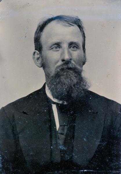
Oliver Hazard Perry DUNCAN
(16 Oct 1836 - 26 Jun 1889)
1 Jun 1850, Great Salt Lake County, Utah, pg 75B.
Oliver Duncan, 22 (1828) born TN, groom.
George Duncan, 17, herds boy, was in same household, which consisted of 17 people. Head of household was Brigham Young.
July 1852, El Dorado Co., CA, pg. 5, line 45;
G. W. [indexed P W at ancestry] Duncan, 20, miner, born Illinois, last residence Illinois
Oliver ?? Duncan, 15, miner, born Illinois, last residence Illinois.
Much info from Ethel Pratt Brown, Guinn's bio and the Duncan book.
Heart Throbs of the West, Vol 9, has Oliver listed as a Mormon Pioneer of 1848 in the Young Company.
Mark registered in Tulare County, CA, Brand book A, pg. 114, has this:
"O. Duncan
Now on this day comes O. Duncan and tenders the Mark in the Margin as the one used by him and having examined the records of Marks & Brands and being satisfied that the same is unlike any in the County and so far as my knowledge extends is different from any in the State I therefore record the same as the legal Mark of said O. Duncan.
Given under my hand as Recorder for Tulare Co., Cal. the 3rd Day of May A.D. 1858
Signed E. E. Calhoun Recorder By Saml K. Dummer, Deputy."
Stamp below his signature says:
"Perpetuated by Matilda & Claude Duncan"
1 Jun 1860, P.O. Visalia, Twp. No. 2, Tulare Co., CA, pg. 21;
Dwelling No. 152: George Dunkin, 28 (1831-32), born IL, farmer, real estate of $2500, personal of $375
Dwelling No. 153: Oliver Duncan, 24 (1835-36), born IL, farmer, real estate of $700, personal of $1750.
Dana Lamb, male, 30 (1829-30), born Vermont, labourer.
Deed dated 20 Dec 1860. John Swanson and Hannah Swanson his wife, of Tulare County, California, recorded Bk D Pg 251, Tulare County records, granted to O.H.P. Duncan of the same county and State, for $200, the following: The Southwest quarter of Section 30 Township 18 South Range 26 East, MDB&M, containing 160 acres. John Swanson signed his name and Hannah Swanson made her mark. Recorded in Book ? Page 251, Tulare County Records. Copy in possession of author.
Brand Registered in Tulare Co., CA, Brand book:
"Oliver Duncan
Now on this day comes Oliver Duncan and tenders the Brand in the Margin as the one used by him, and having examined the Record of Brands, and being satisfied that the same is unlike any other in this County, and so far as my knowledge extends differing from any in the State.
I therefore admit the Same to record as the legal Brand of Oliver Duncan. In Testimony whereof I hereunto set my hand as Recorder of Tulare County this 23d day of October A.D., 1862.
Signed L. S. Bequette Recorder, By P. Bequette, Deputy."
10 Sep 1867, a U. S. Patent was issued to Oliver H. P. Duncan,certificate No. 812, recorded Bk I pg 609 & 610 of Land Patents, Tulare County Records, for 80 acres located at "the East half of the Southeast quarter of Section 29, Township 17 South, Range 22 East, in the District of lands subject to sale at Visalia, California. Copy in possession of author.
8 Apr 1874, a U. S. Patent was issued to Oliver H.P. Duncan, certificate No. 92, Application 291, recorded Book I pg. 610-612 of Land Patents, Tulare County Records, for 160 acres located at The East half of the Southwest quarter and the West half of the Southeast quarter of Section 29, Township 17 South, Range 22 East, Mount Diablo Meridian, in the district of lands subject to sale at Visalia,California. Copy in possession of the author.
1870 Tulare Co., CA, census in Kings River Twp., pg 253, lists the following family:
Oliver Duncan, 38 (1831-32), farmer, born Indiana, value of real estate$1,000, personal estate $2,000
Hannah Duncan, 34 (1836), born Missouri, keeping house
Henry, 9 (1861), born California
Jimmie?, 8 (1862), male, born California
James, 6 (1864) born California
Harriet, 4 (1866) born California
An atlas shows O.H.P. Duncan on the Kings River, the age of this Oliver is correct and ages for Matilda and 4 children would be approximately correct. Hannah was Matilda's mother's name. I have not found any other Oliver Duncan in Tulare County, or in California, in this time period, and think that this much be "my" Oliver in spite of the many glaring differences. Guinn's bio below does indicate that in 1867 he went to Kings River and the two patents also support that.
Tule River Township, Tulare Co., CA, ED 102 pg 10B,
O.H.P. Duncan, 44 (1835-6) born IL, father born TN, mother born U.S. Farmer.
M. Duncan, wife, 37 (1842-43), born IL father born IN mother born OH.
J. W. Duncan, son, 18 (1861-62), born CA both parents born IL
O. K. Duncan, son, 16 (1863-64), born CA both parents born IL
C. V. Duncan, daughter, 13 (1866-67), born CA both parents born IL
May Duncan, daughter, 11 (1868-69), born CA both parents born IL
Pelham Duncan, son, 9 (1870-71), born CA both parents born IL
Ray Duncan, son, 7 (1872-73), born CA both parents born IL
Ada Duncan, daughter, 4 (1875-76), born CA both parents born IL
Hayne Duncan, son, 1 (1878-79), born CA both parents born IL
30 June 1885, U. S. Patent, certificate No. 3571, recorded in Book J page 557 & 558 of Land Patents, Tulare County, California, and was issued to Oliver H. P. Duncan, for 160 acres and 96/100 acre located at the West half of the Northwest quarter and the West half of the Southwest quarter of Section 30 in Township 21 South of Range 29 East, MDB&M, copy of deed in possession of the author.
15 June 1889, recorded Bk 36 page 626 & 627, Tulare County Records, O.H.P. Duncan granted to Matilda Duncan his wife for love and affection "as also for the better maintenance support protection and livlihood of" Matilda Duncan, the South half of the Southwest quarter of Section 27, Township 21 South of Range 31 East, Mount Diablo Meridian containing 80 acres; also Southeast quarter of Section 30 Township 24 South of Range 27 East containing 160 acres. He signed with his mark. This was just a week before his death. Copy in possession of the author.
"100 Year History of the Tule River Mountain Country" by Jeff Edwards, pg 134, has info on Globe (Crabtree) cemetery and birth and death dates of Oliver and others buried there. It says died June 26.
"The History of the State of California" by Prof. J.M. Guinn, 1905, Chicago, The Chapman Publishing Company, has a bio on The Duncans. It says: "As a pioneer citizen of worth and ability, O.H.P. Duncan is remembered by all and honored for the qualities which distinguished his manhood. He was born in Illinois October 16, 1836, and when only sixteen years started across the plains to California. Through a painful and severe accident--the breaking of his thigh--he was compelled to remain a year in Salt Lake City. The following year he came on to California and went to mining in Placerville. After four years of this life he came to Tulare County and engaged in the sheep business, and the following year (1858) he bought 80 acres of land in Deep Creek. After his marriage which occurred in December, 1860, he located on his wife's land, five miles east of Visalia, removing in 1866 to that city while he served as deputy sheriff. In 1867 he went to Kings river, near Kingston, and homesteaded 160 acres and bought 80 acres adjoining, making that location his home until the Spring of 1872. He then moved to Lemon Cove and bought all of the land, 740 acres, which he sold in 1874, then located in Springville. He there purchased 80 acres, including the hotel and springs, and engaged in stock raising for two years. In December, 1876, he went to the South Tule District and bought 160 acres from the railway company. This continued to be his home until his death, June, 1899, after a long and lingering illness following a paralytic stroke."
The same book lists their nine children and states that four are deceased, Oliver K., Clara V., May M. and Hayne. It also says that Mr. Duncan was always active in the counsels of the Democratic Party.
Obituary in Tulare Daily Evening Register, Friday, July 5, 1889.
"O.H.P. Duncan of the South Fork who has been an invalid for years from paralysis died on the 27th inst., and was buried in Rural cemetery on Friday, at 1 o'clock. He was yet in the prime of life, being only 53 years old, but for ten years he has been disabled and seven years nearly or entirely helpless and dependent on his family for every attention. This he has always had. Although Mrs. Duncan has had a hard time to keep her family together and provide for their wants, he was ever her first thought. At last he rests from his trouble and amidst the sympathy felt for the friends bereaved all know it is "better thus.""
On July 6, 1889, the Porterville Enterprise Weekly had this under "Pleasant Valley Items":
"Oliver Duncan died last Thursday at his home on South Tule, after many years of intense suffering. He was buried in the Osborn cemetery."
Copies of both articles in the possession of the author.
http://www.lds.org/churchhistory/library/pioneerdetails/1,15791,4018-1-1994,00.html
Mormon Pioneer Overland Travel, 1847–1868
Duncan, Oliver
Birth Date: 16 Oct. 1836
Death Date: 1890
Gender: Male
Age: 11
Company: Brigham Young Company (1848)
Sources:
Bullock, Thomas, Journals 1843-1849, fd. 1-4. Read Trail Excerpt:
In that Journal is this statement:
"Oliver Duncan, a little boy about 14 while standing on the Wagon Tongue driving. on striking one of his Cattle, his foot slipped, the fore wheel ran over his leg & broke it in two. Dr. Sprague set it as soon as he could. he also reports Sister Groves going on as well as could be expected. she rides in a swing all day—the health of the Camp generally good, but there are some few sick."
From earlier statements, the company was still to the east of Laramie, WY, when this happened. Lucy Groves had fallen under a wagon wheel and had a lower leg broken on June 5. The company has ferried over the Platte River within a few days before Mrs. Groves being hurt and had to cross it again in the entry immediately before Oliver's leg was broken.
A later entry, on Friday, June 16, 1848, has this:
"Dr. Sprague reports health of camp generally well—some few cases of Canker— Sister Groves remains low—her wounds dressed this morning. O. Duncan doing well."
On July 19, 1848, "Had a plain view of Laramie Peak this morning. at same time saw Chimney Rock."
At the end of the journal is a list of where the company camped each night and how many miles the covered each day.
"Wednesday 24, Camped On the Prairie, 11 Miles
Thursday 25, Camped Japion River, 7 Miles
Saturday 27, Camped Elk Horn, 9 Miles
[Total] 27 Miles
>
Monday 5, Camped Liberty Pole on Platte, 12 Miles
Tuesday 6, Camped R.R.& T—same, 13¼ Miles
Wednesday 7, Camped Shell Creek, 10 Miles
Friday 9, Camped Lake South of the road, 18¾ Miles
Saturday 10, Camped Mouth of Looking Glass, 13¼ Miles
[Total] 67¼ Miles
Monday 12, Camped Plum Creek, 16¼ Miles
Tuesday 13, Camped Bluffs Beyond Pawnee town, 17 Miles
Wednesday 14, Camped Upper Ford of Loup Fork, 6¼ Miles
[Total] 39½ Miles
Monday 19, Camped On the Open Prairie, 20 Miles
Tuesday 20, Camped Wood River, 15½ Miles
Wednesday 21, Camped The Bank of the Platte, 14 Miles
Thursday 22, Camped Pioneer Wells, 16 Miles
Friday 23, Camped Pioneer camp ground of 1st May last 15½ Miles
Saturday 24, Camped Open Prairie, banks of Creek, 22 Miles
[Total] 103 Miles
Sunday 25, Camped Banks of the Platte, 7¾ Miles
Wednesday 28 , Camped Camp of 7 & 8 May last, 14¾ Miles
Thursday 29, Camped East side of Sandy Bluffs, 16½ Miles
Friday 30, Camped Good spring of cold water, 17¼ Miles
Saturday July 1, Camped Opposite an Island, 9½ Miles
[Total] 65¾ Miles
Monday 3, Camped West side of small Creek, 14¾ Miles
Tuesday 4, Camped Banks of Platte, 12½ Miles
Wednesday 5, Camped Near Goose Creek, 14 Miles
Thursday 6, Camped Banks of Platte, 14¼ Miles
Friday 7, Camped West foot of Sandy Bluffs, 12¼ Miles
Saturday 8, Camped Opposite “Ash Hollow”, 10½ Miles
[Total] 78¼ Miles
Monday 10, Camped Open Prairie, 13 Miles
Tuesday 11, Camped Opposite some Islands, 14 Miles
Wednesday 12, Camped Ancient Ruins Bluffs, 11¼ miles
Friday 14, Camped Open Prairie, 14 Miles
Saturday 15, Camped Near Chimney Rock, 16 Miles
[Total] 68¼
Monday 17, Camped Open Prairie, 16 Miles
Tuesday 18, Camped Near the River, 14 Miles
Wednesday 19, Camped Banks of Creek, 15½ Miles
Thursday 20, Camped Banks of Platte, 15½ Miles
Friday 21, Camped South side of Platte, 2 Miles
Saturday 22, Camped Beyond Fort Laramie 4 miles, 14 Miles
[Total] 77 Miles
[Total] 526 Miles
Monday 24, Camped Platte Bottom, 5¼ Miles
Tuesday 25, Camped Bitter Creek, 15 Miles
Wednesday 26, Camped On a dry Creek, 15¼ Miles
Thursday 27, Camped Horse Shoe Creek, 3½ Miles
Friday 28, Camped Small Creek (dry), 4¾ Miles
Saturday 29, Camped La Bonte River, 13 Miles
[Total] 56¾ Miles
Sunday 30, Camped Branch of La Bonte, 7 Miles
Tuesday 1 August, Camped A La Prele, 12½ Miles
Wednesday 2, Camped Fourche Boisee’ [Boise], 8½ Miles
Thursday 3, Camped Deer Creek, 9 Miles
Friday 4, Camped Crooked Muddy Creek, 10¼ Miles
Saturday 5, Camped Timber on Platte, 8 Miles
[Total] 55¼ Miles
Sunday 6, Camped 2 Ravines, 6 Miles
Monday 7, Camped Upper Ferry, 4½ Miles
Tuesday 8, Camped Mineral Spring, 12½ Miles
Wednesday 9, Small Spring Creek, 13½ Miles
Thursday 10, Camped Grease Wood Creek, 13 Miles
Friday 11, Camped Independence Rock, 11¼ Miles
Saturday 12, Camped Sweetwater S. side, 10¼ Miles
[Total] 71 Miles
Tuesday 15, Camped Sweetwater S. side, 13 Miles
Wednesday 16 , Camped Sweetwater S. side, 11¼ Miles
Thursday 17, Camped Sweetwater N. side, 8¾ Miles
Friday 18, Camped Sweetwater N. side, 17½ Miles
Saturday 19, Camped Sweetwater S. side, 4 Miles
[Total] 54½ Miles
Monday 21, Camped Sweetwater N. side, 6 Miles
Tuesday 22, Camped Strawberry Creek, 9½ Miles
Wednesday 23, Camped Sweetwater last crossing, 10¾ Miles
[Total] 26¼ Miles
Friday Sept 1, Camped Pacific Creek, 12¾ Miles
Saturday 2, Camped Crossing of Pacific Creek, 1½ Miles
[Total] 14¼ Miles
Sunday 3, Camped Dry Sandy, 9 Miles
Monday, Camped Little Sandy, 13¾ Miles
Tuesday 5, Camped Big Sandy, 8¼ Miles
Wednesday 6, Camped Big Sandy, 17 Miles
Thursday 7, Camped Green River, 15 Miles
Friday 8, Camped Black’s Fork, 15½ Miles
Saturday 9, Camped Black’s Fork, 15½ Miles
[Total] 94 Miles
Monday 11, Camped Black’s Fork, 11¼ Miles
Tuesday 12, Camped High Land Creek, 18¼ Miles
Wednesday 13, Camped Sulphur Creek, 20 Miles
Thursday 14, Camped A clear Spring, 9½ Miles
Friday 15, Camped Cache Cave, 7 Miles
Saturday 16, Camped Echo Creek, 6½ Miles
[Total] 70½ Miles
Monday 18, Camped Red Fork of Weber, 17 Miles
Tuesday 19, Camped Kanyon Creek, 15½ Milwa
Wednesday 20, Camped Near Brown’s Creek, 12¼ MIlwa
Thursday 21, Camped Last Creek, 9 Miles
Friday 22, Great Salt Lake City, 7¾ Miles
[Total] 61½ Miles
[Total] 86 / 1031 Miles
Average 12
86 traveling days at an average of 12 miles per day 1032 [Miles]
36 days lay still
Total 122 days from Winter Quarters to Great Salt Lake City"
Oliver Duncan, 22 (1828) born TN, groom.
George Duncan, 17, herds boy, was in same household, which consisted of 17 people. Head of household was Brigham Young.
July 1852, El Dorado Co., CA, pg. 5, line 45;
G. W. [indexed P W at ancestry] Duncan, 20, miner, born Illinois, last residence Illinois
Oliver ?? Duncan, 15, miner, born Illinois, last residence Illinois.
Much info from Ethel Pratt Brown, Guinn's bio and the Duncan book.
Heart Throbs of the West, Vol 9, has Oliver listed as a Mormon Pioneer of 1848 in the Young Company.
Mark registered in Tulare County, CA, Brand book A, pg. 114, has this:
"O. Duncan
Now on this day comes O. Duncan and tenders the Mark in the Margin as the one used by him and having examined the records of Marks & Brands and being satisfied that the same is unlike any in the County and so far as my knowledge extends is different from any in the State I therefore record the same as the legal Mark of said O. Duncan.
Given under my hand as Recorder for Tulare Co., Cal. the 3rd Day of May A.D. 1858
Signed E. E. Calhoun Recorder By Saml K. Dummer, Deputy."
Stamp below his signature says:
"Perpetuated by Matilda & Claude Duncan"
1 Jun 1860, P.O. Visalia, Twp. No. 2, Tulare Co., CA, pg. 21;
Dwelling No. 152: George Dunkin, 28 (1831-32), born IL, farmer, real estate of $2500, personal of $375
Dwelling No. 153: Oliver Duncan, 24 (1835-36), born IL, farmer, real estate of $700, personal of $1750.
Dana Lamb, male, 30 (1829-30), born Vermont, labourer.
Deed dated 20 Dec 1860. John Swanson and Hannah Swanson his wife, of Tulare County, California, recorded Bk D Pg 251, Tulare County records, granted to O.H.P. Duncan of the same county and State, for $200, the following: The Southwest quarter of Section 30 Township 18 South Range 26 East, MDB&M, containing 160 acres. John Swanson signed his name and Hannah Swanson made her mark. Recorded in Book ? Page 251, Tulare County Records. Copy in possession of author.
Brand Registered in Tulare Co., CA, Brand book:
"Oliver Duncan
Now on this day comes Oliver Duncan and tenders the Brand in the Margin as the one used by him, and having examined the Record of Brands, and being satisfied that the same is unlike any other in this County, and so far as my knowledge extends differing from any in the State.
I therefore admit the Same to record as the legal Brand of Oliver Duncan. In Testimony whereof I hereunto set my hand as Recorder of Tulare County this 23d day of October A.D., 1862.
Signed L. S. Bequette Recorder, By P. Bequette, Deputy."
10 Sep 1867, a U. S. Patent was issued to Oliver H. P. Duncan,certificate No. 812, recorded Bk I pg 609 & 610 of Land Patents, Tulare County Records, for 80 acres located at "the East half of the Southeast quarter of Section 29, Township 17 South, Range 22 East, in the District of lands subject to sale at Visalia, California. Copy in possession of author.
8 Apr 1874, a U. S. Patent was issued to Oliver H.P. Duncan, certificate No. 92, Application 291, recorded Book I pg. 610-612 of Land Patents, Tulare County Records, for 160 acres located at The East half of the Southwest quarter and the West half of the Southeast quarter of Section 29, Township 17 South, Range 22 East, Mount Diablo Meridian, in the district of lands subject to sale at Visalia,California. Copy in possession of the author.
1870 Tulare Co., CA, census in Kings River Twp., pg 253, lists the following family:
Oliver Duncan, 38 (1831-32), farmer, born Indiana, value of real estate$1,000, personal estate $2,000
Hannah Duncan, 34 (1836), born Missouri, keeping house
Henry, 9 (1861), born California
Jimmie?, 8 (1862), male, born California
James, 6 (1864) born California
Harriet, 4 (1866) born California
An atlas shows O.H.P. Duncan on the Kings River, the age of this Oliver is correct and ages for Matilda and 4 children would be approximately correct. Hannah was Matilda's mother's name. I have not found any other Oliver Duncan in Tulare County, or in California, in this time period, and think that this much be "my" Oliver in spite of the many glaring differences. Guinn's bio below does indicate that in 1867 he went to Kings River and the two patents also support that.
Tule River Township, Tulare Co., CA, ED 102 pg 10B,
O.H.P. Duncan, 44 (1835-6) born IL, father born TN, mother born U.S. Farmer.
M. Duncan, wife, 37 (1842-43), born IL father born IN mother born OH.
J. W. Duncan, son, 18 (1861-62), born CA both parents born IL
O. K. Duncan, son, 16 (1863-64), born CA both parents born IL
C. V. Duncan, daughter, 13 (1866-67), born CA both parents born IL
May Duncan, daughter, 11 (1868-69), born CA both parents born IL
Pelham Duncan, son, 9 (1870-71), born CA both parents born IL
Ray Duncan, son, 7 (1872-73), born CA both parents born IL
Ada Duncan, daughter, 4 (1875-76), born CA both parents born IL
Hayne Duncan, son, 1 (1878-79), born CA both parents born IL
30 June 1885, U. S. Patent, certificate No. 3571, recorded in Book J page 557 & 558 of Land Patents, Tulare County, California, and was issued to Oliver H. P. Duncan, for 160 acres and 96/100 acre located at the West half of the Northwest quarter and the West half of the Southwest quarter of Section 30 in Township 21 South of Range 29 East, MDB&M, copy of deed in possession of the author.
15 June 1889, recorded Bk 36 page 626 & 627, Tulare County Records, O.H.P. Duncan granted to Matilda Duncan his wife for love and affection "as also for the better maintenance support protection and livlihood of" Matilda Duncan, the South half of the Southwest quarter of Section 27, Township 21 South of Range 31 East, Mount Diablo Meridian containing 80 acres; also Southeast quarter of Section 30 Township 24 South of Range 27 East containing 160 acres. He signed with his mark. This was just a week before his death. Copy in possession of the author.
"100 Year History of the Tule River Mountain Country" by Jeff Edwards, pg 134, has info on Globe (Crabtree) cemetery and birth and death dates of Oliver and others buried there. It says died June 26.
"The History of the State of California" by Prof. J.M. Guinn, 1905, Chicago, The Chapman Publishing Company, has a bio on The Duncans. It says: "As a pioneer citizen of worth and ability, O.H.P. Duncan is remembered by all and honored for the qualities which distinguished his manhood. He was born in Illinois October 16, 1836, and when only sixteen years started across the plains to California. Through a painful and severe accident--the breaking of his thigh--he was compelled to remain a year in Salt Lake City. The following year he came on to California and went to mining in Placerville. After four years of this life he came to Tulare County and engaged in the sheep business, and the following year (1858) he bought 80 acres of land in Deep Creek. After his marriage which occurred in December, 1860, he located on his wife's land, five miles east of Visalia, removing in 1866 to that city while he served as deputy sheriff. In 1867 he went to Kings river, near Kingston, and homesteaded 160 acres and bought 80 acres adjoining, making that location his home until the Spring of 1872. He then moved to Lemon Cove and bought all of the land, 740 acres, which he sold in 1874, then located in Springville. He there purchased 80 acres, including the hotel and springs, and engaged in stock raising for two years. In December, 1876, he went to the South Tule District and bought 160 acres from the railway company. This continued to be his home until his death, June, 1899, after a long and lingering illness following a paralytic stroke."
The same book lists their nine children and states that four are deceased, Oliver K., Clara V., May M. and Hayne. It also says that Mr. Duncan was always active in the counsels of the Democratic Party.
Obituary in Tulare Daily Evening Register, Friday, July 5, 1889.
"O.H.P. Duncan of the South Fork who has been an invalid for years from paralysis died on the 27th inst., and was buried in Rural cemetery on Friday, at 1 o'clock. He was yet in the prime of life, being only 53 years old, but for ten years he has been disabled and seven years nearly or entirely helpless and dependent on his family for every attention. This he has always had. Although Mrs. Duncan has had a hard time to keep her family together and provide for their wants, he was ever her first thought. At last he rests from his trouble and amidst the sympathy felt for the friends bereaved all know it is "better thus.""
On July 6, 1889, the Porterville Enterprise Weekly had this under "Pleasant Valley Items":
"Oliver Duncan died last Thursday at his home on South Tule, after many years of intense suffering. He was buried in the Osborn cemetery."
Copies of both articles in the possession of the author.
http://www.lds.org/churchhistory/library/pioneerdetails/1,15791,4018-1-1994,00.html
Mormon Pioneer Overland Travel, 1847–1868
Duncan, Oliver
Birth Date: 16 Oct. 1836
Death Date: 1890
Gender: Male
Age: 11
Company: Brigham Young Company (1848)
Sources:
Bullock, Thomas, Journals 1843-1849, fd. 1-4. Read Trail Excerpt:
In that Journal is this statement:
"Oliver Duncan, a little boy about 14 while standing on the Wagon Tongue driving. on striking one of his Cattle, his foot slipped, the fore wheel ran over his leg & broke it in two. Dr. Sprague set it as soon as he could. he also reports Sister Groves going on as well as could be expected. she rides in a swing all day—the health of the Camp generally good, but there are some few sick."
From earlier statements, the company was still to the east of Laramie, WY, when this happened. Lucy Groves had fallen under a wagon wheel and had a lower leg broken on June 5. The company has ferried over the Platte River within a few days before Mrs. Groves being hurt and had to cross it again in the entry immediately before Oliver's leg was broken.
A later entry, on Friday, June 16, 1848, has this:
"Dr. Sprague reports health of camp generally well—some few cases of Canker— Sister Groves remains low—her wounds dressed this morning. O. Duncan doing well."
On July 19, 1848, "Had a plain view of Laramie Peak this morning. at same time saw Chimney Rock."
At the end of the journal is a list of where the company camped each night and how many miles the covered each day.
"Wednesday 24, Camped On the Prairie, 11 Miles
Thursday 25, Camped Japion River, 7 Miles
Saturday 27, Camped Elk Horn, 9 Miles
[Total] 27 Miles
Monday 5, Camped Liberty Pole on Platte, 12 Miles
Tuesday 6, Camped R.R.& T—same, 13¼ Miles
Wednesday 7, Camped Shell Creek, 10 Miles
Friday 9, Camped Lake South of the road, 18¾ Miles
Saturday 10, Camped Mouth of Looking Glass, 13¼ Miles
[Total] 67¼ Miles
Monday 12, Camped Plum Creek, 16¼ Miles
Tuesday 13, Camped Bluffs Beyond Pawnee town, 17 Miles
Wednesday 14, Camped Upper Ford of Loup Fork, 6¼ Miles
[Total] 39½ Miles
Monday 19, Camped On the Open Prairie, 20 Miles
Tuesday 20, Camped Wood River, 15½ Miles
Wednesday 21, Camped The Bank of the Platte, 14 Miles
Thursday 22, Camped Pioneer Wells, 16 Miles
Friday 23, Camped Pioneer camp ground of 1st May last 15½ Miles
Saturday 24, Camped Open Prairie, banks of Creek, 22 Miles
[Total] 103 Miles
Sunday 25, Camped Banks of the Platte, 7¾ Miles
Wednesday 28 , Camped Camp of 7 & 8 May last, 14¾ Miles
Thursday 29, Camped East side of Sandy Bluffs, 16½ Miles
Friday 30, Camped Good spring of cold water, 17¼ Miles
Saturday July 1, Camped Opposite an Island, 9½ Miles
[Total] 65¾ Miles
Monday 3, Camped West side of small Creek, 14¾ Miles
Tuesday 4, Camped Banks of Platte, 12½ Miles
Wednesday 5, Camped Near Goose Creek, 14 Miles
Thursday 6, Camped Banks of Platte, 14¼ Miles
Friday 7, Camped West foot of Sandy Bluffs, 12¼ Miles
Saturday 8, Camped Opposite “Ash Hollow”, 10½ Miles
[Total] 78¼ Miles
Monday 10, Camped Open Prairie, 13 Miles
Tuesday 11, Camped Opposite some Islands, 14 Miles
Wednesday 12, Camped Ancient Ruins Bluffs, 11¼ miles
Friday 14, Camped Open Prairie, 14 Miles
Saturday 15, Camped Near Chimney Rock, 16 Miles
[Total] 68¼
Monday 17, Camped Open Prairie, 16 Miles
Tuesday 18, Camped Near the River, 14 Miles
Wednesday 19, Camped Banks of Creek, 15½ Miles
Thursday 20, Camped Banks of Platte, 15½ Miles
Friday 21, Camped South side of Platte, 2 Miles
Saturday 22, Camped Beyond Fort Laramie 4 miles, 14 Miles
[Total] 77 Miles
[Total] 526 Miles
Monday 24, Camped Platte Bottom, 5¼ Miles
Tuesday 25, Camped Bitter Creek, 15 Miles
Wednesday 26, Camped On a dry Creek, 15¼ Miles
Thursday 27, Camped Horse Shoe Creek, 3½ Miles
Friday 28, Camped Small Creek (dry), 4¾ Miles
Saturday 29, Camped La Bonte River, 13 Miles
[Total] 56¾ Miles
Sunday 30, Camped Branch of La Bonte, 7 Miles
Tuesday 1 August, Camped A La Prele, 12½ Miles
Wednesday 2, Camped Fourche Boisee’ [Boise], 8½ Miles
Thursday 3, Camped Deer Creek, 9 Miles
Friday 4, Camped Crooked Muddy Creek, 10¼ Miles
Saturday 5, Camped Timber on Platte, 8 Miles
[Total] 55¼ Miles
Sunday 6, Camped 2 Ravines, 6 Miles
Monday 7, Camped Upper Ferry, 4½ Miles
Tuesday 8, Camped Mineral Spring, 12½ Miles
Wednesday 9, Small Spring Creek, 13½ Miles
Thursday 10, Camped Grease Wood Creek, 13 Miles
Friday 11, Camped Independence Rock, 11¼ Miles
Saturday 12, Camped Sweetwater S. side, 10¼ Miles
[Total] 71 Miles
Tuesday 15, Camped Sweetwater S. side, 13 Miles
Wednesday 16 , Camped Sweetwater S. side, 11¼ Miles
Thursday 17, Camped Sweetwater N. side, 8¾ Miles
Friday 18, Camped Sweetwater N. side, 17½ Miles
Saturday 19, Camped Sweetwater S. side, 4 Miles
[Total] 54½ Miles
Monday 21, Camped Sweetwater N. side, 6 Miles
Tuesday 22, Camped Strawberry Creek, 9½ Miles
Wednesday 23, Camped Sweetwater last crossing, 10¾ Miles
[Total] 26¼ Miles
Friday Sept 1, Camped Pacific Creek, 12¾ Miles
Saturday 2, Camped Crossing of Pacific Creek, 1½ Miles
[Total] 14¼ Miles
Sunday 3, Camped Dry Sandy, 9 Miles
Monday, Camped Little Sandy, 13¾ Miles
Tuesday 5, Camped Big Sandy, 8¼ Miles
Wednesday 6, Camped Big Sandy, 17 Miles
Thursday 7, Camped Green River, 15 Miles
Friday 8, Camped Black’s Fork, 15½ Miles
Saturday 9, Camped Black’s Fork, 15½ Miles
[Total] 94 Miles
Monday 11, Camped Black’s Fork, 11¼ Miles
Tuesday 12, Camped High Land Creek, 18¼ Miles
Wednesday 13, Camped Sulphur Creek, 20 Miles
Thursday 14, Camped A clear Spring, 9½ Miles
Friday 15, Camped Cache Cave, 7 Miles
Saturday 16, Camped Echo Creek, 6½ Miles
[Total] 70½ Miles
Monday 18, Camped Red Fork of Weber, 17 Miles
Tuesday 19, Camped Kanyon Creek, 15½ Milwa
Wednesday 20, Camped Near Brown’s Creek, 12¼ MIlwa
Thursday 21, Camped Last Creek, 9 Miles
Friday 22, Great Salt Lake City, 7¾ Miles
[Total] 61½ Miles
[Total] 86 / 1031 Miles
Average 12
86 traveling days at an average of 12 miles per day 1032 [Miles]
36 days lay still
Total 122 days from Winter Quarters to Great Salt Lake City"
Events
| Birth | 16 Oct 1836 | Belleville, St. Clair Co., Illinois |  | ||
| Census | 1 Jun 1850 | Great Salt Lake County, Utah Territory | |||
| Census | Jul 1852 | pg. 5, line 40, El Dorado Co., California | |||
| Brand Registration | 3 May 1858 | See Notes for detail. - Tulare Co., California | |||
| Court Records | 3 May 1858 | O. Duncan filed his mark Vol A pg 113 Tulare County marks and brands. This mark was perpetuated by Matilda & Claude Duncan - Tulare Co., California | |||
| Property Sale | 2 May 1860 | Book ? Pg 175-177, Oliver Duncan to James L. Wells both of Tulare County for $300, NW qtr of NE qtr S23 T18S R26E MDB&M, 40 acres. - Tulare Co., California | |||
| Census | 1 Jun 1860 | Tulare Co., California | |||
| Marriage | 13 Dec 1860 | Visalia, Tulare Co., California - Matilda SWANSON | | ||
| Property | 20 Dec 1860 | Bk D pg 251, Tulare County, CA; John Swanson and Hannah his wife grant to O.H.P. Duncan for $200: SW qtr of Sec 30 Twp 18 South Range 26 East, MDB&M, containing 160 acres. - Tulare Co., California | |||
| Property | 23 Sep 1861 | Bk D page 476, Tulare County. William Duncan to Oliver H.P. Duncan both of Tulare Co. for $300, North half of West fractional half of fractional SW qtr S26 T19S R26E MDB&M, 36 10/100 acres. - Tulare Co., California | |||
| Court Records | 23 Oct 1862 | Oliver Duncan registered his brand. - Tulare Co., California | |||
| Brand Registration | 23 Oct 1862 | See Notes for detail. - Tulare Co., California | |||
| Voting Register | 25 Jul 1866 | Register 1873 shows Oliver Hazard Perry Duncan. age 29, born U.S., Deputy Sheriff resident Kings River Precinct. - Tulare Co., California | |||
| Property | 10 Sep 1867 | Patent recorded Bk I pg 609 to Oliver H.P. Duncan. East half SE qtr S29 T 17S R22E, 80 acres. - Tulare Co., California | |||
| Property | 8 Apr 1874 | Patent recorded Bk I pg 610 to Oliver H.P. Duncan. East half SW qtr & West half SE qtr S29 T17S R22E MDB&M., 160 acres. - Tulare Co., California | |||
| Voting Register | 18 Mar 1878 | Age 42, born Illinois, farmer in Porterville. - Tulare Co., California | |||
| Census | 9 Jun 1880 | Tule River Twp., Tulare Co., California | |||
| Property | 30 Jun 1885 | Patent recorded Bk J pg 557 to Oliver H.P. Duncan. West half NWw qtr and West half of SW qtr S30 T21S R29E MDB&M. 161 96/100 acres. - Tulare Co., California | |||
| Property Sale | 15 Jun 1889 | Book 36 page 626. Deed from O.H.P. Duncan to Matilda Duncan, wife, for love and affection. S half SW qtr S27 T21S R31E MDB&M, 160 acres. - Tulare Co., California | |||
| Death | 26 Jun 1889 | Success Valley, Tulare Co., California | | ||
| Burial | Aft 26 Jun 1889 | Old Crabtree Cemetery, Globe, Tulare Co, California | |||
| Obituary | 5 Jul 1889 | Extract of Tulare Daily Evening Register, 1889, states on July 5 that Oliver died on June 27. Burial in Rural Cemetery on Friday. Age 53 [1836]. In Porterville News section. - Tulare Co., California | |||
| Reference No | 824 |
Families
| Spouse | Matilda SWANSON (1843 - 1926) |
| Child | John William DUNCAN (1861 - 1905) |
| Child | Oliver Knight DUNCAN (1863 - 1888) |
| Child | Clara Virginia DUNCAN (1866 - 1886) |
| Child | Matilda May DUNCAN (1868 - 1886) |
| Child | Pelham George DUNCAN (1871 - 1909) |
| Child | Ray Myron DUNCAN (1873 - 1929) |
| Child | Adah Irene DUNCAN (1875 - 1965) |
| Child | Hayne DUNCAN (1878 - 1894) |
| Child | Claude DUNCAN (1884 - 1946) |
| Father | William A. DUNCAN (1803 - 1847) |
| Mother | Dolly H. DUNCAN (1811 - 1846) |
| Sibling | James Madison DUNCAN (1828 - ) |
| Sibling | George Washington DUNCAN (1832 - 1911) |
| Sibling | William Pekin DUNCAN (1840 - 1907) |
| Sibling | Hulda Caroline DUNCAN (1845 - 1921) |
Endnotes
1. J. M. Guinn (Prof.), The History of the State of California (Name: The Chapman Publishing Company, Chicago, 1905;).
2. O.H.P. Duncan/Madilda Swanson Marriage Certificate, Bk A, pg 31, Tulare County Records.
3. Obituary.